 Thursday, May 10, 2007
400 Miles
Location For The Night: Braemar Castle Hostel, Braemer, TN
Miles Walked Today: 24.00
Day Number:
25
I got up and off today at 6:04am, good daylight but before sunup. All my bunkmates were still snoozing. According to the guidebook I passed the 400 mile mark at approximately 8:50. Big deal. But how far you've been and how far you've got left to go cannot be the focus. One day at a time with Mount Katahdin at the fore is the focus. Just get in today's miles, enjoy the journey, and remain focused on the ultimate goal. I carry a little postage stamp size picture of Katahdin in my wallet. It's a photo taken across a lake from about 40 miles away. I look at it from time to time to remind me to remain focused.
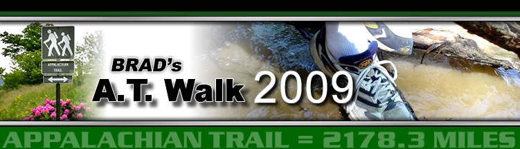
At 2:00pm I reached a parking lot that serves the Laurel Falls area. There were a lot of day hikers and frequent side trails. There was a recommended alternate (blue blaze) trail that bypassed Laurel Gorge. The white blaze AT trail took me all the way down into Laurel Gorge to the base of Laurel Falls. It was a sight to behold. Breathtaking. I took a picture but the sun was high in the sky and it looks washed out to me so today's photo is a smaller stream that the trail crossed earlier this morning. Upon leaving the falls the trail climbs up out of the gorge to the top of Pond Mountain, another exceptionally tough climb.
My heart goes out to all the many hikers out here, the majority, that are carrying 40 to 60 pound loads up these kind of grades. I could not, would not, wish such on my worst enemy. I really do not know how they keep going. In comparison my pack today, with 3 days of food and a quart of water, weighed about 18 pounds. This is the main reason I can do the miles I'm doing, this and God's good grace. If I had a 45 pound pack up here, as many, many do, I would stop at the next town, buy a bus ticket to Paducah, and leave the pack and its contents behind for some hearty soul with more strength and will than I have. Thanks Ray and Jenny for opening my eyes.
Well, even with my meager 18 pounds I was very happy to finally reach the crest of Pond Mountain. From there I called Sutton Brown, owner of Brown's Store and Braemar Castle Hostel, an old two-story stone structure built years ago by the railroad that Sutton has converted to a hostel, a very nice hostel indeed. Sutton picked me up at the trailhead on Watauga Lake at 6:30pm. I am in a private room with a bath. No, as I told you before, this is not cheating. It was never my intent to do this thing on a shoestring like some of these kids are forced to do.
I took a shower, got supplies at Sutton's Store, and hitched a ride to the McDonald's in Hampton, TN, where I consumed two Big Mac's, a large fry and a drink. Then I hitched a ride back to the hostel. Thanks to both of you guys that gave me rides. After I returned Sutton and I talked awhile as I ate a pint of Ben & Jerry's Chunky Monkey ice cream. We talked about the weather, Tony Blair, George Bush, liberals and conservatives, and, before taking my leave to type this report, we had pretty well ironed out everything that needed ironing out regarding all the above.
So, to put an end to my jabbering, today I started at Mountaineer Shelter, mile 394.2, and ended at US Highway 321, mile 418.2, a total of 24 miles even for the day. That's 96 laps around Tilghman's track with elevation changes in the multiple thousands of feet.
 Friday, May 11, 2007
Lonely Day
Location For The Night: Double Springs Shelter
Miles Walked Today: 23.00
Day Number:
26
Today I was up at 5:00am. I packed up and cooked breakfast at the hostel. I fixed scrambled eggs with cheddar cheese, six slices of bacon and a sweet roll. To drink I had a pint of orange juice and a pint of chocolate milk. For this endeavor food is of supreme importance. I couldn't eat it all so I made a bacon and egg burrito for the trail. The accommodating Mr. Brown had me back to the trailhead at Watauga Lake at 7:15. Thanks Sutton.
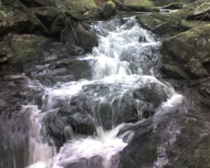
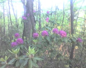
Blackberries are in bloom up here now. The blooms have a sweet perfume like fragrance. The mountain laurel is spotty. Some places it has bloomed and the blossoms are dropping off, mostly in the lower elevations. Other places, even down low, it hasn't started to bloom. I keep looking for it to come into its own. Today's photo is of the first full rhododendron bloom I have seen to date. The photo was taken this morning.
Much of the day was spent up on a high ridge walking through the Big Laurel Branch Wilderness. There were a lot of little ups and downs. I saw five whitetail deer today and a wild turkey. The turkey took off through the trees just a few feet away from me. It was scary. It flew straight like a bullet, beating its wings against leaves and branches.
This afternoon, upon leaving Big Laurel Branch Wilderness, the trail crossed a gravel road and meandered through an grassy farm field for about 3/4 mile. This is the first time is over 400 miles that this has happened.
Until I arrived at camp tonight I had seen the same number of people on the trail today as I did animals, five. They were headed north and I passed all of them. Other than that it was a lonely day. So lonely that on the flat easy spots I almost went to sleep. I actually found myself nodding off and had to stop for a quick ten minute nap. Don't want to walk of the side of the trail and end up down the side of the mountain somewhere.
Sort of a boring report for today if you ask me. I'll try to do better tomorrow but right now I am extremely, yes extremely, tired. I started today at US Highway 321, mile 418.2, and ended up at Double Spring Shelter, mile 441.2, a total of 23.0 miles for the day. God bless you all.
 Saturday, May 12, 2007
King of the Road
Location For The Night: Montgomery Homestead B&B, Damascus, VA
Miles Walked Today: 18.30
Day Number:
27
I left camp late this morning at 7:15. I knew this would be a short day, 18 miles or so. It was cloudy and threatening rain.
Everything is lush and green now, the soft, tender green of springtime. The bright yellow-orange Flame Azaleas are in bloom. I see more of them along the trail each day. The forest canopy, except for elevations above 4500', is fully formed making for plenty of shade on the trail. What a wonderful creation our God has wrought.
But with the full canopy comes reduced visibility. We are, as author Bill Bryson has so eloquently noted, experiencing 'a walk in the woods'. Former scenic views are now shrouded by green leaves. Thinking of all those leaves, you may be wondering (probably not) how I navigate.
Map and compass are unnecessary on the AT. I use guidebook pages as does most everyone else. I only carry the pages for one section at a time, from one drop box location to the next. I do this to save weight. The guidebook (I'm using Wingfoot's Thru-hikers's Guide.) provides all the information you need: distances, shelters and campsites, water sources, road crossings, resupply and lodging information. Today getting lost on the AT would be difficult. If you can follow 2" X 6" white blazes you can find your way to Maine.
There were two groups of trail angels today. At 8:45am when I arrived at Low Gap where the AT crosses US421, Ruby and Brenda Price, mother and daughter, greeted me with a table full of goodies. They are from Shady Valley, TN, and this is a ministry of Shady Valley Baptist Church. I heartily partook of their wares and prayed that the Lord would bless them for their ministry to hungry hikers. Thanks Ruby and Brenda. Then, at 11:08, just four miles up the trail at McQueen's Gap, USFS Road 69, Jeff and Linda Austin of First Baptist Church in Damascus, VA, were waiting with more delicious food. I had just eaten my trail breakfast and wasn't all that hungry until Linda brought out a big tray of fresh fruit with some of that creamy fruit dip. Sorry, but there weren't many strawberries left for the next guy. I washed them down with chocolate milk and put a sausage biscuit in my pack for later. Thanks Jeff and Linda.
For the past several days, all day long, two songs have been running through my mind, "King of the Road" by Roger Miller (because I fly out of Bangor, MN, when this is over) and "Victory in Jesus" because those of us that are trusting Him truly do have Victory. He is 'My Savior Forever'. These songs were on my mind so strongly I looked them up and printed the words at the bottom of this entry. Read them if you wish.
At 2:03pm I crossed into Virginia from Tennessee. (photo) Goodbye North Carolina and Tennessee. At 3:00 I heard carnival music. At 3:25 I walked off the mountainside into Damascus, VA, with both shoulder straps still securely attached to my pack. Sure enough there was a carnival in town. The AT went right through the middle of it. It was here to kick off a week long Trail Days celebration that culminates next weekend with all the primary events. This is a big, big deal on the trail. I planned to be here in time for it, but I'm eleven days ahead of my schedule. That means I have a choice, hitch a ride back to Damascus next weekend or keep on walking. If I hitch back, as many will, then I have to hitch forward to get back on where I got off. Complicated, huh?
I picked up my drop box at Mount Rogers Outfitters, checked into the last room at Miss Susie Montgomery's Homestead, took a shower, shaved, did my laundry (while eating ice cream), laid down for 40 minutes, ate lasagna at Sicily's Pizza & Subs and came back to my room to converse with you.
Miss Susie says tomorrow morning's breakfast is at 8:00. I plan to be there. And, both Miss Susie and trail angels, Jeff and Linda Austin (I saw them again at supper tonight), invited me to join them at First Baptist of Damascus. I will be there also, for Sunday school and church. Tomorrow, as you may have guessed, will be my first zero day. I've been waiting for my body to tell me when to rest. It has. I and my body plan to rest ALL afternoon.
Long, long entry tonight, but I've got AC power to charge this battery. Today I walked from Double Springs Shelter, mile 441.2, to Damascus, VA, mile 459.5, a total for the day of 18.3 miles.
PS: Maybe I should change the 'Campsite' location at the top of these reports to hostel or hotel as it seems I've been frequenting both. In any case tonight I'm at the Montgomery Homestead B&B in a delightfully comfortable room with my own bath and TV. I just hope I left Gil enough money to cover all these charge card debits.
KING OF THE ROAD
Trailer for sale or rent
Rooms to let...fifty cents.
No phone, no pool, no pets
I ain't got no cigarettes
Ah, but..two hours of pushin' broom
Buys an eight by twelve four-bit room
I'm a man of means by no means
King of the road.
Third boxcar, midnight train
Destination...Bangor, Maine.
Old worn out clothes and shoes,
I don't pay no union dues,
I smoke old stogies I have found
Short, but not too big around
I'm a man of means by no means
King of the road.
I know every engineer on every train
All of their children, and all of their names
And every handout in every town
And every lock that ain't locked
When no one's around.
I sing,
Trailers for sale or rent
Rooms to let, fifty cents
No phone, no pool, no pets
I ain't got no cigarettes
Ah, but, two hours of pushin' broom
Buys an eight by twelve four-bit room
I'm a man of means by no means
King of the road.
VICTORY IN JESUS
I heard an old, old story,
How a Savior came from glory,
How He gave His life on Calvary
To save a wretch like me;
I heard about His groaning,
Of His precious blood's atoning,
Then I repented of my sins;
And won the victory.
Chorus:
O victory in Jesus,
My Savior, forever.
He sought me and bought me
With His redeeming blood;
He loved me ere I knew Him,
And all my love is due Him,
He plunged me to victory,
Beneath the cleansing flood. I heard about His healing,
Of His cleansing power revealing.
How He made the lame to walk again
And caused the blind to see;
And then I cried, "Dear Jesus,
Come and heal my broken spirit,"
And somehow Jesus came and brought
To me the victory.
Chorus:
I heard about a mansion
He has built for me in glory.
And I heard about the streets of gold
Beyond the crystal sea;
About the angels singing,
And the old redemption story,
And some sweet day I'll sing up there
The song of victory.
 Sunday, May 13, 2007
Day of Rest
Location For The Night: Montgomery Homestead B&B, Damascus, VA
Miles Walked Today: 0.00
Day Number:
28
First I want to wish all the moms in my life a very happy Mother's Day. You know who you are. Thank all of you for all you do for my boys and all my grandchildren. And thank all of you moms that are not part of my immediate family. God bless you all.
Today I rested a tired body. This is my 28th day on the trail and my first zero day and it happened to fall on the day the Lord rested. I feel like it has helped to revitalize both body and spirit.
Breakfast was served at 8:00 sharp. We had an egg casserole, bacon, homemade pecan sticky buns, cheese grits and watermelon. To drink there was coffee, apple juice and grape juice.
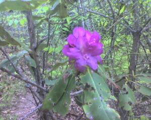
I went to Sunday school and church at First Baptist, Damascus (photo). Gaines Montgomery, Miss Susie's husband, took me to his Sunday school class, a good bunch of guys with lots of prayer needs. I added mine for both my family and myself and our teacher, Stan, prayed for all of us. During the service the church voted to buy 30 acres on the outskirts of town to build a new church, so this was a big day for First Baptist, Damascus.
After church I walked down the street for a grilled chicken salad lunch and ice cream. I got a cheeseburger to go for tonight so I wouldn't have to get out again. Then, for the most part, I rested all afternoon. I did take some cold weather clothing and some odds and ends I haven't been using across the street to Mt. Rogers Outfitters for them to mail back home tomorrow.
I attended Sunday night service at First Baptist too. My plan is to leave at 6:00am tomorrow, missing breakfast here. I don't want to hang around until 9:00 to start walking.
 Monday, May 14, 2007
Right Diagnosis
Location For The Night: Stealth Site, about .8 mile north of Whitetop Mtn. Road, USFS Road 89
Miles Walked Today: 22.00
Day Number:
29
I left Damascus, elevation 1928', at 6:00am. Tonight I stopped walking at 5.20pm. I'm camped at approximately elevation 5350'. That's a bit of climbing. The longer I'm out here, however, the easier it gets. I've learned to pace myself. And the day of rest in Damascus was just what the doctor ordered. It really made a difference today. I was stronger and felt rejuvenated in every way. I am happy I listened to Dr. Body.
There's a guy that claims he's through hiking this thing barefoot. I met him at church yesterday before Sunday school. He had flip-flops on in the church house but he slipped one off to show me his feet. They did look like he'd been walking barefoot. He needed a pedicure. I asked why he had flip-flops on if he hiked barefoot every day. He said to be presentable. I saw him again about 6:20 this morning as I was leaving Damascus. He was out on the front porch of a house on the north side of town. I'd like to actually see him barefoot on the trail. If I do I'll let you know.
For the first 10 miles or so this morning the trail meandered back and forth along an old railroad that's been converted to a biking path. You see it off and on, but it's near the trail and they both run alongside a creek that's rushing down the mountain toward Damascus. The name of the bike path is the Virginia Creeper, it's all downhill, and it's become big business for Damascus. Bike rentals run rampant there. The rental places shuttle their customers up to the top of the path and they coast all the way back to town. Most of their energy is expended applying the brakes. It does run through some gorgeous country.
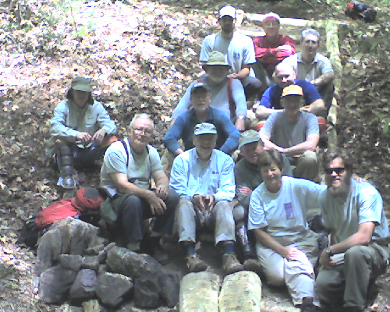
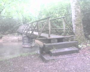
At 12:10pm I had the honor of being the first hiker to cross a new bridge that had just been completed by a volunteers with the Konnarock Trail Crew from Sugar Grove, VA. Ted Wilson was the leader. He's bottom right in today's photo. Part of the new bridge is visible at the very bottom of the picture and they are sitting on the new steps they built to get down to the bridge. These folks were from all over the nation and it was evident they were enjoying working on the trail.
I had dehydrated refried beans and Oreos for supper tonight. They were good. Today I left Damascus, VA, mile 459.5 (elv. 1928'), and walked up to a campsite at about mile 481.5 (elv. 5350'), a total of 22.0 mostly uphill miles. It was a beautiful cool, sunny day and it's getting cold here at 8:39. I hope I didn't send that extra pair of long johns home too soon. God bless all of you.
 Tuesday, May 15, 2007
Beautiful Scenery
Location For The Night: Hurricane Mountain Shelter
Miles Walked Today: 22.00
Day Number:
30
This morning I left camp at 6:33. As I walked toward the Mount Rogers area I was reminded of the Smokies. The creeks, trees, moss, ferns, trail, and dead fall are all similar. At VA Highway 600 at Elk Garden, Mount Rogers, the highest mountain in Virginia, came into view. This area, and the adjacent Grayson Highlands north of Mount Rogers, are mostly balds. They abound in scenic views. They also abound in rocks. Almost the entire route through this beautiful area is over a very rocky trail. It makes for slow going for about 4 miles. But, if you are looking for a wonderful place to do some section hiking and want to experience a little bit of everything that the AT has to offer (so far) this would be it. It is magnificent. Today's photo is one this year's foal of one of the miniature mares grazing in the Grayson Highlands. These small horses are habituated to hikers that feed them. They walk right up to you begging for food.
I estimate I passed at least 60 people hiking south toward Damascus today, an exodus. It was as if political genocide was occurring in the next county and its residents were leaving fast with all their belongings. They are headed for Trail Days, the big blowout (they expect 25,000 visitors) I told you about that... it's coming up this next weekend in Damascus. Some are section hikers, timing their itinerary to get there on Thursday or Friday. Many are south-to-north through hikers like me that have shuttled forward (north) and are hiking backwards (south) with full packs so they will be in Damascus for Trail Days. How is this a through hike? If one is traveling from Point A to Point B, one must travel "through" certain geographical areas to get to from Point A to Point B. In so doing is it logical that one would jump ahead (by whatever means), travel backwards toward Point A from which he had departed, and call this part of his journey? If I do this thing it's going to be the whole deal from south to north following the white blazes while carrying all my gear and supplies. I've talked about this enough. I won't mention it again.
At 3:13pm I saw two turkeys up on a steep bank to the left of the trail. They scurried off into the woods.
I passed the 500 mile mark at about 4:00pm. Today I walked from approximately mile 481.5, to Hurricane Mountain Shelter, mile 503.5, a total for the day of 22.0 miles. Residing here with me tonight are WillieGoat, Trail Dancer, Snack, Skip, Tenderfoot and Smarty Jones. They have all been agreeable and docile so far. Skip just said he screams in sleep. God bless you all.
 Wednesday, May 16, 2007
Spring or Not?
Location For The Night: Partnership Shelter
Miles Walked Today: 19.80
Day Number:
31
As far as I could tell Skip did not scream last night. Maybe the old boy was pulling our legs.
I wish I knew more about when to expect the mountain laurel and rhododendron (photo) to open up and cover the mountainside. It's obvious that they bloom later at the higher elevations. But, as I mentioned recently, the blooms are spotty, just here and there. Most of the blooms for both species seem to be about ready to burst forth any day now.
My daily mileage has picked up to the point that I am able to bypass some of my planned food resupply locations. With the increased mileage I have food left over from the previous resupply, and that food added to the new resupply food enables me to go farther with fewer stops. This is good because going into towns, particularly those off the trail, is time consuming. With that said I will go into Atkins, VA, tomorrow to pick up a box.
You may be wondering about some of the guys I've been with in the past. I don't know where Gimpy is. He took at least one zero in Hot Springs and I haven't heard from him since. Hans is hiking with a bunch of kids that wanted to be in Damascus for Trail Days this coming Friday, so he is way behind. Flaxseed did not take a zero in Damascus as I did so he's ahead if me by about a half a day. I can tell this by his entries in the trail registries that we sign as we enter and exit the various park areas. He said he is going back for Trail Days. I have decided that I will not. I've been to carnivals before and 25,000 visitors in that little town will be exactly that, one big carnival. I'll pass.
Today was another wonderful day spent walking in the woods. I left camp at 6:17am. At 11:54 I entered a pasture field where cattle were grazing. There was an old barn and some out buildings there. It started to rain and the wind picked up at about 1:30 on top of Brushy Mountain, a long high ridge. It was still raining and getting harder at 3:20pm when I arrived at Partnership Shelter near the Mount Rogers NRA Headquarters. I decided to stay put. And, as a bonus, this shelter features running water and a hot shower - free. Boy did that shower feel good.
I bought postcards at the Visitor's Center here and wrote notes to many in my family. Supper was some kind of Lipton rice dinner (good), tortillas with pre-cooked bacon, a Hershey bar, and a Three Musketeers bar. They had candy at the Visitor's Center too.
Today I left Hurricane Mountain Shelter, mile 503.5, and am bedded down tonight at Partnership Shelter, mile 523.2, a total of 19.8 miles for the day. God bless all of you.
 Thursday, May 17, 2007
Retirement Day
Location For The Night: Knot Maul Branch Shelter
Miles Walked Today: 25.50
Day Number:
32
It was cold again last night, probably 38-40 degrees, cold enough to make it tough to roll out of the sack. But, I was up and going at 6:20. I slipped the postcards under the door of the Visitor's Center to be mailed and I was on my way.
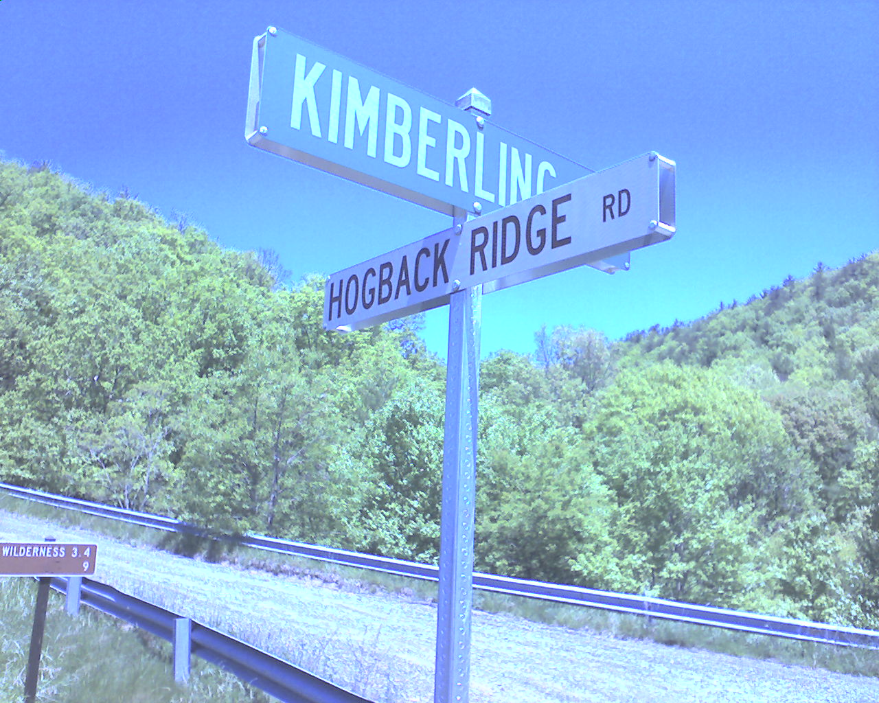
Let me explain these "ridges" we walk on up here. Several days ago I told you I stayed at a Shelter named Hogback Ridge. It was named after the ridge where it is located. All these ridges could be named Hogback, because, for the most part, they are up and down like the vertebrae on a razorback hog. I'm not talking about the severe climbs up from the gaps, the trail towns, and the highways. I'm talking about the profile of the ridges once you are on top of them. The ups and downs are not as great, say 100' to 200' vertical at a time, but it is still up and down and up and down.
Now for a synopsis of the day: at 8:09 I saw a deer snorting on the trail in 75 yards ahead. It jumped into the woods as I was getting out my camera. At 9:07 I ate breakfast on top of Glade Mountain; granola, raisins, powdered milk, tortillas with bacon, M&Ms. At 11:15 I passed the Settler's Museum living history farm where an old fashioned one room school was in session. The schoolmarm asked if I had completed the 5th Primer. At 11:56 I met up with three members of the Piedmont AT Hikers (PATH) working on the trail. They are responsible for maintaining this section of the AT. I thanked them for their work At 12:20 I was at I-81 near Atkins, VA. My resupply box was at a motel right on the trail. I ate ate a quick stop (hamburger, ham sandwich, two Tropicana drinks, a pint of ice cream, and a pint of chocolate milk), packed my stuff, charged my PDA batteries, and was back in the trail at 2:20. Thanks to the family that sent me the homemade granola.
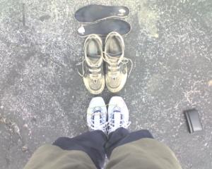
I got new shoes in this resupply, the second of four pairs for the entire trip. I'm about a forth of the way to Katahdin, so it was time. Today's photo shows the retirement ceremony for the loyal Asics that have been with me for 534 miles as they pass over the Ring Trick to their replacement, a new pair of New Balance. It was touching. Moments later the faithful Asics were in a dumpster.
I left I-81 behind at 2:20 and even with the additional resupply weight I felt strong all afternoon. The trail was good, not many rocks and roots and I turned out some miles. And, this afternoon,
for the first time, I walked through a section where the rhododendron and flame azaleas had really come into their own.
Today I started at Partnership Shelter, mile 523.2, and ended at 7:30pm just before it started raining again. I here at Knot Maul Branch Shelter (the book spells it 'maul', the sign here says 'mole'), mile 548.7, a total for the day of 25.5 miles. It's good to be dry with the pitter-patter of the rain on this metal roof. I'm here tonight with Wagos (With A Grain Of Salt), 55, of Chicago. God bless all of you.
 Friday, May 18, 2007
Rocky Ridge
Location For The Night: Jenkins Shelter
Miles Walked Today: 19.00
Day Number:
33
Today dawned cold, cloudy and windy and it remained that way most of the day. I left camp at 6:40am. This afternoon it rained off and on. It's still cold tonight but seems to be clearing up. Maybe it will warm up tomorrow.
There were not many flowers along the trail today as most of the day was spent high up on the ridges walking on rocky trail. It's difficult to explain how it feels to walk hour after hour over rocks. Well, maybe not too difficult. It feels like walking over rocks hour after hour. You have to be careful. It slows you down and makes you tired.
There is new light green growth on the fir and hemlock trees. It gives me a feeling of new life. I ate lunch today high on Chestnut Knob (4410') at the shelter there. At 3:40 there was a cooler with water and Gatorade on the trail - trail magic. All the Gatorade was gone but the water was appreciated. Thanks. At 3:50 I saw two deer and at 5:02 I saw a chipmunk.
I was not able to get a signal to send yesterday's entry today. I stopped on top of the ridge several times to try to send it but no luck. This is the first time since I started walking that I have not posted either the night of the entry or the next morning.
Today I walked from Knot Maul Shelter, mile 548.7, to Jenkins Shelter, mile 567.7, a total of 19.0 hard, rocky miles today. Today's photo is the footbridge over Lick Creek. Here with me at Jenkins tonight are Robo, Still Walking and Whisper.
 Saturday, May 19, 2007
Clear Blue Sky
Location For The Night: Jenny Knob Shelter
Miles Walked Today: 23.60
Day Number:
34
It was cold again last night, maybe the coldest since I started. I'd guess it 35 degrees or so. Before the night was over I had most of my wardrobe on. But this morning the sky was clear. What a wonderful feeling to leave camp at 6:20 with the promise of blue sky and sunshine. Within minutes I was shedding clothes. Thank you Lord for a day like today.
Today's route was much easier than yesterday, fewer rocks and a better trail, a lot of it cushioned by leaves and pine needles.
There have been gypsy moth traps alongside the trail for the past three days. This afternoon I saw a sign announcing a date for aerial spraying for gypsy moths. They must be a problem here.
At 8:38 where the trail crosses VA615 there was a cooler full of Gatorade - trail magic. This time there were plenty of full bottles and I enjoyed a lemon-lime. On top of the cooler was a sheet of paper with the week's weather report and the Scripture verses, John 4:13&14, which apply to Gatorade as well as water. Thanks trail angels. At 11:49 near the road to Bland, VA, more trail magic, a case of Dr. Pepper and several gallon jugs of water on the side of the trail. Thanks again. I was scheduled to resupply in Bland but I have enough food to get to Pearisburg, VA, where I pick up my next box from home. I just kept on walking. At 12:05 I was able to get a signal and send the past two days reports while crossing over Interstate-71. I was just past I-71 when I took today's photo, another Hogback Ridge.
I climbed a Brushy Mountain this morning and another one this afternoon. Tomorrow morning there is another Brushy Mountain coming up. There have already been several Brushies before today. A popular name, and it got me to thinking. You could get by with about three names for these hills and hollows; Big Mountain, Deep Gap (there's been several of these two), and Hogback Ridge. That would cover it. Climb up, up Big Mountain, up and down along Hogback Ridge, and down, down to Deep Gap. And then do it all over again, and again, and again. What a deal. A barrel of fun. By the way, when the trail follows old logging roads it is usually easier to walk because the logging roads were graded for horses, not men. Even the horses had it better than we do.
Today I walked from Jenkins Shelter, mile 567.7, to Jenny Knob Shelter, mile 591.3, a total of 23.6 miles for the day. I'm here tonight with Salty Dog and J.P. J.P. says hello to his family in Dallas. Salty Dog says there ain't no deadlines on the AT. Please pray for my left shin. I have some pain there and I pray it's not the beginning of shin splints. God bless you all.
|